For those that use Google Maps regularly, you might have noticed a handy feature that appeared in the Android app.
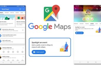
Google Maps for Android now lets users add a public event in the Contribute Tab. Using Google Maps’ new feature can let business and event managers make public their next events without the need of paying for advertising. It takes nearly 30 minutes to make that event live once it was added on Google Maps.
The new feature is only available for Android users at the moment. Now let’s see how you can set your public event in the short guide below.
Google Maps: Add a Public Event
Looking at the support page from Google, we can see that the feature is not live in all regions, so if you don’t see it, then you’ll have to wait for your region to be added. To see the option and add a public event, follow the next steps:
- open Google Maps on Android -> go to the tab Contribute -> tap on Events, then tap on Add a public event.
In there, you will get a few choices: you can tag the location, add the event name, and the time and date of the event.
The option also lets you add an image and write more details about the event and even describe it. However, there have been reports of the image option being unresponsive.
Save the event, and if you want, even after you have created the event, you can edit or delete it by going to:
- Contribute -> Events -> Select your event -> Edit this event / Delete this event.
We don’t know yet if this feature will be globally available or if it will also go live on Google Maps for iPhone users.
Google Maps Changes, New Features and More
According to Debate Report, Google Street View now lets you watch “Mars on Earth,” and it’s definitely not what we expected.
Google has also made a few changes to the Maps for Android, reintroducing city, state and country borders, after being removed a few months ago. When a user searches a city, state or country, they will see the borders highlighted with red. According to reports, this border feature has appeared in version 10.12.1.